On this page (6 sections)
The airport in one view
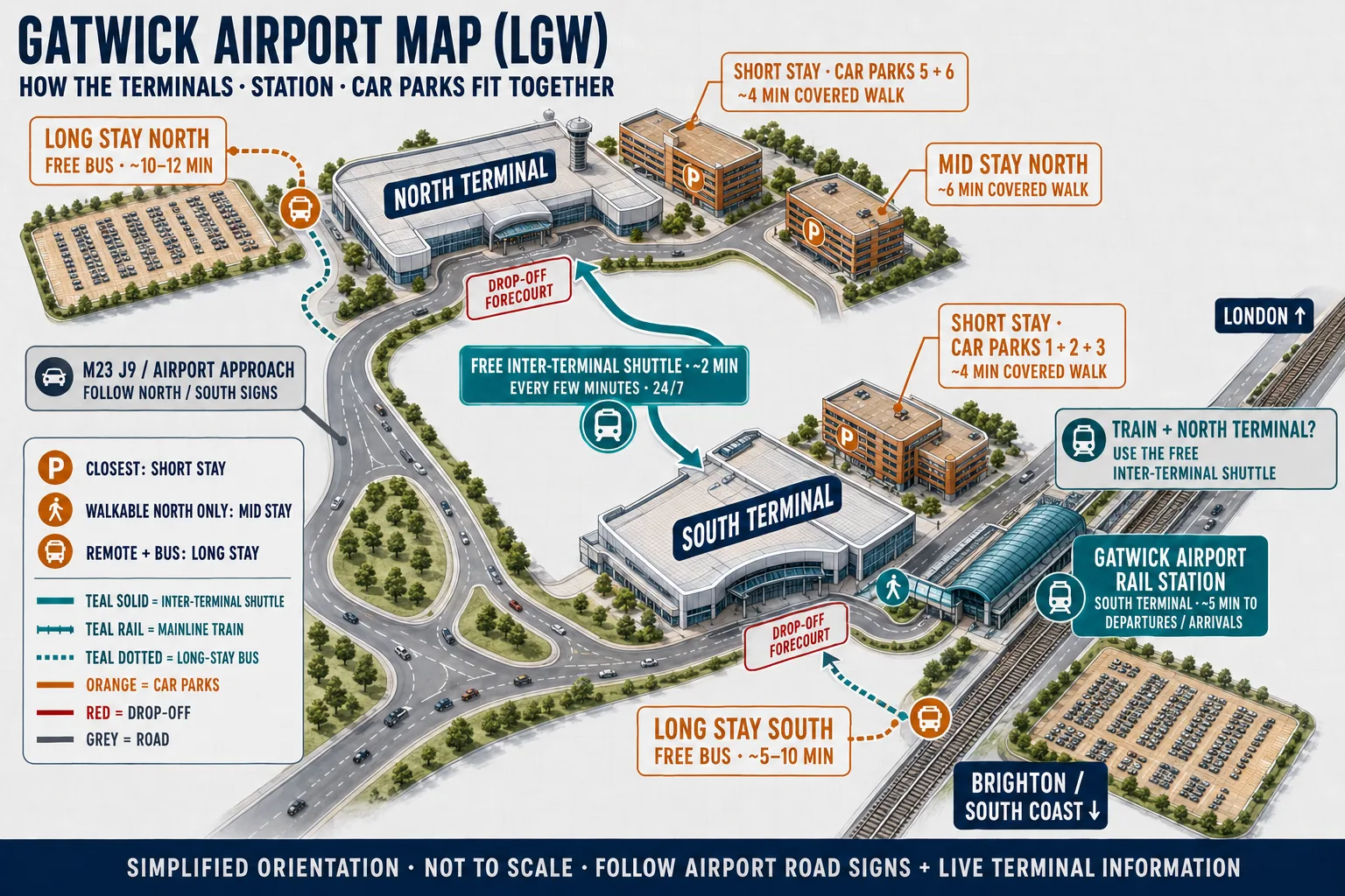
Start with the runway, because everything else hangs off it. Gatwick's single runway runs east to west along the southern edge of the airfield, 3,316 metres of it, with a shorter standby strip immediately to its north that is used only when the main runway is closed. Everything a passenger touches sits north of the runways: the piers and aircraft stands first, then the two terminal buildings, then the car parks, hotels and perimeter roads fanning out behind them.
The eastern edge belongs to the railway. The Brighton Main Line runs north to south past the airport, and Gatwick Airport station sits on it, built directly into the South Terminal. The M23 spur arrives from the east too, splitting into signed approaches for each terminal before you reach any building. The South Terminal is the one beside the station and the motorway spur; the North Terminal stands about a kilometre away to the north-west, joined to its twin by an elevated shuttle track. That is the whole estate: two buildings, one runway, one station, and a two-minute ride between the halves.
The two terminals
The South Terminal is the original and the bigger of the two, about 160,000 square metres against the North's 98,000, and it holds the station, which makes it the natural front door for anyone arriving by rail. Around 35 airlines use it, led by British Airways, with Vueling, Wizz Air, Ryanair and Norwegian among the names alongside. The North Terminal, opened in 1988, is easyJet's home at Gatwick, with Emirates and most of the long-haul leisure carriers beside it, about 24 airlines in all. TUI splits between the two by flight number: BY flights use South, TOM flights use North.
Which one you need is set by your airline, not by preference, and allocations move, so check the terminal printed on your booking and confirm against which terminal your airline uses if there is any doubt. The full guides cover each building in depth, everything at North and everything at South, and the terminals overview compares the pair side by side if you are still orienting yourself.
The station and the shuttle
Gatwick Airport station is part of the South Terminal, about a five-minute walk from both departures and arrivals, with seven platforms and step-free access throughout. A train leaves on average every four minutes, so for most journeys the station is the fastest way in and out of the airport. The station guide covers the platforms, the walkway and the operators in detail.
The shuttle is how the two halves of the airport connect. It boards close to the station in the South Terminal, runs every five minutes for most of the day (every ten between 23:00 and 06:00), and covers the 1.2km to the North Terminal in two to three minutes, free, driverless and running around the clock. Luggage trolleys roll straight on. Flying from North after arriving by train means station, shuttle, check-in, and about ten minutes door to door; the terminal shuttle guide has the boarding points and step-free detail. A signed landside walking route also links the terminals, though the airport publishes no walking time for it and the shuttle wins on every practical measure.
Roads, drop-off and car parks
By road, Gatwick hangs off the M23 at Junction 9, with the A23 running past and the M25 about ten minutes north at Junction 7. The spur splits by terminal before the airport proper, so the first sign you obey is North or South, then the purpose: drop-off, short stay, long stay or car hire return. Set the sat nav to RH6 0PJ for the North Terminal or RH6 0NP for the South, and the postcode and address guide lists the codes for the car parks too.
The parking follows a simple ring pattern: short stay multi-storeys stand next to each terminal (a four-minute covered walk), premium closer still, and the long stay fields sit out on the perimeter roads with a free bus every 10 to 12 minutes that takes about as long again. The drop-off forecourts outside each terminal are camera-enforced and charged, £10 for ten minutes, while the long stay car parks give two hours free, which is the sensible way to meet or wait; the drop-off guide and the full parking guide carry the rates and the tactics. Coaches use the South Terminal's lower forecourt at stops 1 and 5 and the lower level outside international arrivals at North.
Finding your way inside
Gatwick's own maps number the floors in tens, and the convention helps once you know it: Level 00 is the lowest, with Levels 10, 20 and 30 stacked above. At the South Terminal, check-in fills Level 20 in zones lettered A to K, the same level as the arrivals concourse and the station walkway, with security one floor up on Level 30 and the gates on Piers 1, 2 and 3. At the North Terminal, arrivals and the forecourt sit at Level 00, the shuttle link and self-service kiosks on Level 10, and the main check-in hall (zones A to E) and security on Level 20, with gates on Piers 4, 5 and 6.
That is deliberately the short version. The floor plans deserve their own pages, so the North Terminal map and the South Terminal map walk each building level by level: where the check-in zones, security lanes, lounges, left luggage and pier walks actually are, and how long to allow between them.
Finding a specific shop or your gate
These pages give you the layout, which does not change from one week to the next: the levels, the zones, the piers, and how long to allow between them. Two things move too fast to map, and both are easy to pin down on the day: which shop is trading where this month, and your gate number, which the airline assigns close to departure.
Your gate is printed on your boarding pass and shown on the departure screens the moment it is called, and the departures board here carries the scheduled time and terminal before you leave home. Shops and food change too often to fix in a diagram, but each terminal has directory boards and clear signage from the moment you clear security, so the current line-up is in front of you exactly when you need it. Use these pages to understand the airport and budget your time, and the building itself fills in the rest.